PLATFORM PREVIEW
See the full platform in action. Real terrain. Real data. Real time.
25+ Data Feeds
3D Terrain + Entities
Financial Modeling
Risk Scoring
7 AI Agents
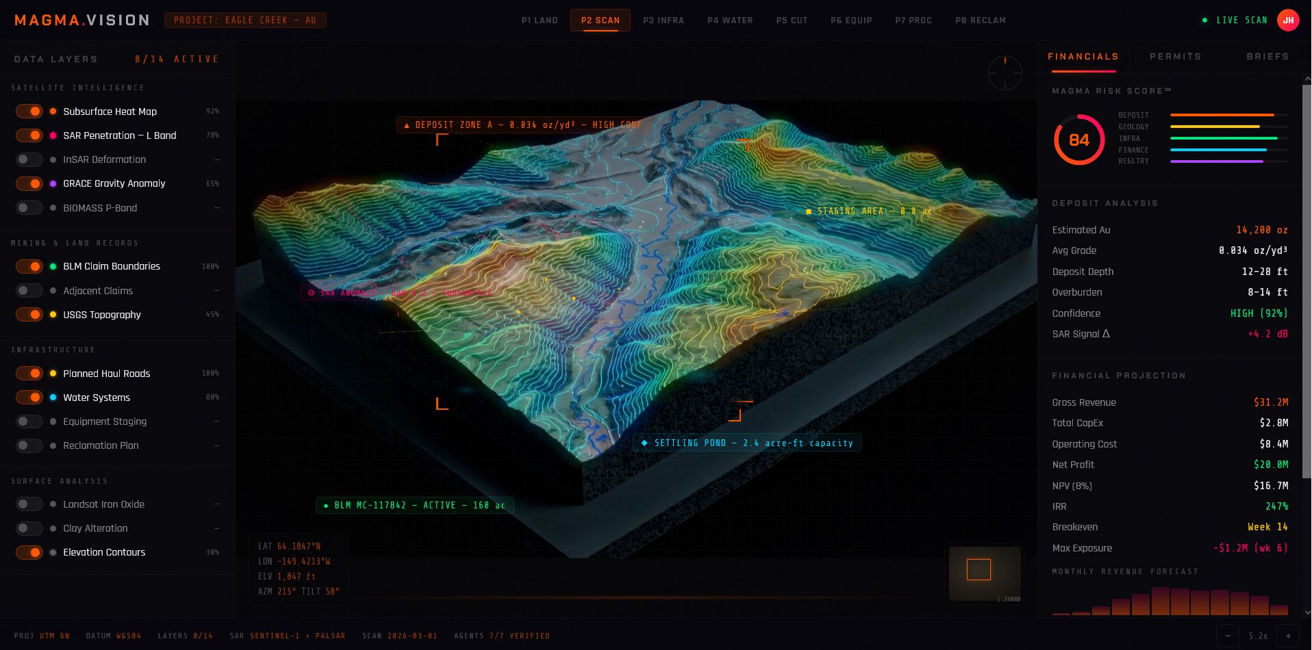
AI-Powered Geospatial Intelligence for Mining. One platform. Every data layer. From satellite to shovel.
Miners commit millions before knowing what's underground. 60% of exploration projects fail due to inadequate pre-development intelligence.
Satellite imagery, soil surveys, claim records, permits, hydrology — all in separate systems, different formats. No single source of truth.
12–18 month permit cycles with manual processes. One missed filing can cost an entire operating season and hundreds of thousands in delays.
Gold mining alone is a $220B/yr industry. The consulting layer adds $30B+ in services.
Sentinel-2, USGS, BLM, NWS, NOAA — all integrated into a single real-time view.
CesiumJS + MapTiler — interactive globe with real terrain, overlays, and entity tracking.
7 specialized agents: geology, cost estimation, logistics, water, finance, verification, presentation.
Proprietary 0–100 confidence metric synthesizing all data layers into a single decision signal.
Bare land acquisition & baseline survey. Environmental snapshot before anything moves.
Satellite scanning, SAR analysis & deposit identification. AI-driven confidence scoring.
Infrastructure planning, access roads & staging areas. Cost modeling per scenario.
Water systems design, discharge permitting & settling pond engineering.
Cut planning, earthworks modeling & volume calculations. Overburden analysis.
Equipment logistics, fleet optimization & cycle time modeling.
Processing, sluice recovery tracking & yield optimization. Real-time grade monitoring.
Reclamation planning, revegetation tracking & compliance closure documentation.
We license the MAGMA.VISION platform directly to gold mining operators, giving them real-time geospatial intelligence, AI-driven site analysis, and end-to-end project tracking from exploration to reclamation.
We earn revenue from our wholesale accounts when clients order equipment through us, plus commissions on third-party services including diamond drilling, satellite scans, and consulting contracts.
We use the enterprise version of our own technology to identify and secure promising mining assets, then flip those mines with our software stack included — capturing both the operational and technology premium on exit.
No competitor unifies satellite imagery, geological surveys, claims data, hydrology, weather, and compliance into a single view. We do.
7 specialized AI agents work in parallel — geology, cost estimation, logistics, water systems, financial modeling, verification, and presentation.
Proprietary 0–100 scoring synthesizes all data layers into a single confidence metric. Validated against historical mine performance.
Built for mission-critical decisions. Real-time 3D terrain, phase-based workflows, and automated compliance tracking — not a toy dashboard.
"Every new site trained on the platform makes the AI smarter for the next one."
Rolling close. Join us in building the operating system for modern gold mining.